One of the biggest aims for agrifoodtech startups is giving farmers more information and insight into what is happening with their crops.
From sensors to satellites to soil tests, entrepreneurs are taking a variety of routes to helping farmers make smarter, more efficient, and more profitable decisions.
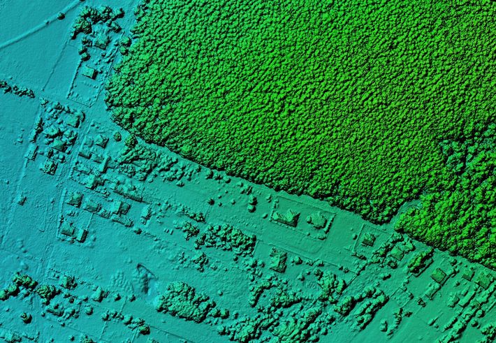
For The Climate Corporation, geospatial imaging has emerged as a particularly promising technology.
“I am excited about this journey we’re on of using data science and digital tools to shift from simply providing growers with high performing inputs to where we are more often providing them with solutions that meet the most pressing needs they have,” Jeremy Williams, head of The Climate Corporation and digital farming at Bayer Crop Science, tells AFN.
Williams is participating on a panel at the October 6, 2021, AgTech NEXT conference addressing the intersection of AgTech and Geospatial. Specific panel topics include how that intersection can help growers make informed decisions that benefit their bottom line and the environment, and in turn, help us move the needle on climate change.
This year, AgTech NEXT is offering a three-part conference series focusing on different aspects of climate change.
Click here to view the entire list of speakers and panelists for the final two events and register. Tickets are complimentary.
In general, geospatial imaging involves location-based imaging that provides a way to monitor living things and non-living things, according to Williams. Being able to tie an image to a specific location is key.
“If you are a farmer and you want to understand how your crop is progressing, whether there is any evidence of disease or insects that need to be treated, you can use drone imagery or satellite imagery. And because you have the location information, you can actually then decide where in the field you have an issue and whether you need to look at it or apply treatment.”
Geospatial technology has been making major improvements, according to Williams. This includes better resolution in images, smaller images, and the ability to glean geospatial data from drones.
“We’re excited about drones as they become more available from a regulatory perspective and how that will enhance what we can do in terms of monitoring conditions on the farm.”
Read on to learn more from Williams (JW) about how The Climate Corporation is working with geospatial imaging, how it’s deploying the technology, and whether farmers are eagerly adopting it.
AFN: How have farmers responded to geospatial imaging technology so far?
JW: In general, farmers are largely in favor because they understand how this can improve the quality of their operations instead of having to go walk every field, for example, or drive every field. Because they can also control whether their fields are enrolled or not in our service, they can control what is done with the data. I think that gives farmers comfort that the data will be useful to them but not used in ways that they might not approve of.
AFN: Sometimes how the technology is rolled out or integrated is more important than the technology itself. What are some lessons you’ve learned about giving farmers geospatial imaging?
JW: The technology has to be simple to use and easy to understand what the value is. One of the general takeaways is that if things are highly complex that always slows down adoption. The other thing is that the technology has to be robust and needs to work when it’s needed. We’ve invested significantly in making sure our FieldView platform is robust and scalable. We look very closely at the feedback from growers about where we can do even better going forward or what some of the missing features are that they would like to have. A big part of their overall comfort has to do with growers being confident that the data is going to be useful to them and not in ways that they don’t approve of. We’ve always been very transparent about how the growers own the data.
AFN: What are some of the challenges around deploying geospatial imaging in agriculture?
JW: Some of the challenges, which are not really unique to geospatial imaging, is that the resolution is maybe not as high as you’d like for all the applications you’re interested in. The number of times that you can sample in terms of the satellite images may not be as frequent as you would want. The cost is often higher than would be desirable for broad application. So, these three things — resolution, frequency of updates, and costs — are things that have to improve over time.
AFN: Looking into the future, can you share any hints about how we might see The Climate Corporation use geospatial imaging in the future?
JW: One of the things I am really excited about is drone technology and how it can enable much more precise agriculture and sustainable agriculture. We are particularly interested in how drones can be used to detect weeds and then over time, be used as delivery vehicles for applying herbicides in a more precise way. We’re also pretty excited about using drones to help us identify disease early or conditions that might lead to disease and, over time, being able to use drones to deliver fungicides more precisely. So, I think you’re going to see a lot more tailored prescriptions and precision agriculture all enabled by increasing resolution from satellite imagery, but even more importantly, using drones for both detection and application.
AFN: What are you hoping to get out of AgTech NEXT?
JW: I am looking forward to meeting the other panelists and hearing about their journey in this space and what have been some of their key learnings. The other is just continuing to identify opportunities for collaboration because as capable as many of our companies are including Bayer Crop Science and Climate, we are convinced that as an industry we will make much more significant progress and make it more quickly if we leverage collaboration. I am looking forward to understanding what additional opportunities there are for collaboration as part of AgTech NEXT.