Satellite imaging startup Astro Digital has raised $16.65 million in Series A funding from a group of family offices, including existing investors.
Agriculture is a key sector of focus for Astro Digital, which counts farm management software and big data analytics companies among its clients in the sector.
The startup will use the funding to accelerate the launch of Astro Digital’s Landmapper constellation; it is planning eight launches for 2017 with the first slated for eight to 10 weeks time.
“2016 was a bad year for launches with lots of delays generally in the industry so we raised a bit more capital with this round so we could be much more aggressive in building up our launch capacity,” said Bronwyn Agrios, cofounder. “So instead of doing one-to-two launches in 2017, we really wanted to de-risk the business and we’re doing four launches of nine satellites.”
Daily imaging by 2018
This means Astro Digital’s first constellation will be 80% launched this year, including one satellite with high-resolution imaging capabilities, much earlier than previously planned, according to Agrios. With these launches, Agrios says the company will be able to provide images every two days, but with another launch in early 2018, she hopes to provide daily imaging by the end of Q1 2018.
“We want to be able to provide a data point every week by the 2018 growing season, and ultimately, 90 images, in a combination of resolutions, per growing season,” she added.
All of these images means a lot of data to process and store, so the startup is also using the funding to work on its analytics platform.
Analytical focus
Instead of waiting for its first satellites to be in orbit, Astro Digital has been building its analytics platform from day one using publicly-available satellite imagery from Landsat.
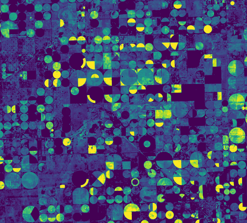
The startup has worked on turning these images into vegetation maps, which indicate the health of plants by measuring the level of chlorophyll in the leaves based on how much light is reflected off them. These maps use NDVI (Normalized Difference Vegetation Index) and can help users to understand the current stage of crop growth compared to previous images, and produce a yield estimate based on that growth rate.
Astro Digital plans to give clients real-time alerts about changes in their fields based on these vegetation maps, which could relate to disease or drought, for example.
The aim is to make satellite imagery accessible to clients and relatively simple to use and gain insights from, says Agrios.
Agriculture clients
Astro Digital’s agriculture clients include farm data services such as Agrible, as well as insurance companies and hedge funds keen to understand yields predictions for each growing season.
“Astro Digital technology brings a true value to Agrible customers in production ag and the crop insurance markets,” said Chris Harbourt, CEO at Agrible. “The high satellite revisit frequency coupled with quality data is exactly what we need to deliver timely, quality analysis with proper context to our customers and partners.”
The way Astro Digital presents the data it collects from the imagery varies, but most likely clients will receive a data feed in a string of numbers or set of alerts to feed into their own software and algorithm, said Agrios.
“We’re not an answers company, we’re a tooling company that provides the building blocks to allow anyone to work with satellite imagery,” she said. “Some of our more sophisticated clients know how to work with raw data sets, but they don’t want it at the volumes we’ll be getting it, so we need to be smart about how we’re presenting it so as not to put the burden of storage, processing, and analysis on the end user.”
Satellite imagery is a core component of most ag data and farm management software solutions today. It can complement data coming off farm machinery, drones, and weather data, as FarmersEdge is using it. Climate Corporation is also hoping to integrate satellite imagery with a network of sensors. FarmLogs believes ground sensing can be beneficial, but that satellite imagery is the most scalable and reliable source of data for farm decision support.
Image: Time series analysis of farmland from Astro Digital. “What’s cool about this is that it’s a static picture, but we are encoding each pixel with a time series. So within this image we have the story of the entire season,” says Agrios. “In this case, we built a model to pull out large fluctuations that may indicate something unintentional like disease or intentional like harvest. Yellow is how we are representing the large fluctuations. We used Landsat as the input into this analysis. With updates every 2 weeks, we aren’t really able to see the minor fluctuations needed to act upon. The daily high-frequency data we’ll get from Landmapper will give us a really granular look at the how fields are maturing so we can take action immediately when our model detects a signal, such as for disease.


