Editor’s Note: Phil Cruver is CEO of Catalina Sea Ranch, which recently raised $1.5 million in funding for the first offshore aquaculture facility in US Federal waters. As well as farming mussells and later other seafood, CSR is also embarking on creating a wireless data capturing system for the ocean, which it’s trademarked as The Ocean Internet of Things.
Here Cruver explains a bit more about what this system will measure, and the technologies and partner organizations involved in this endeavor.
————
Oceans function as a sink for pollutants. They help regulate the global climate by absorbing gasses, which would otherwise heat the atmosphere. But having absorbed roughly one-third of the carbon dioxide produced by human activities during the industrial era, oceans have become 30 percent more acidic. This threatens to knock the marine food web off balance and lessen the ocean’s uptake of carbon dioxide.
The consequences this will have on the ability to produce certain types of seafood is alarming, and mollusk shellfish, which represent a $1 billion industry in the US, are particularly sensitive to ocean acidification.
As we at Catalina Sea Ranch (CSR) make progress towards growing mussels in the first permitted offshore aquaculture facility off the Californian coast in US Federal waters, it will be critical for us to monitor the impact of ocean acidification. And we’re in a good 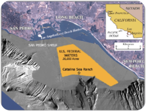 position to do so, with a ranch on the edge of the San Pedro Shelf, plunging 150 feet to 3,000 feet deep and the site of upwelling. The ranch experiences the phenomenon of massive upwelling lifting nutrients from the deep seafloor to the surface for producing phytoplankton which is the food for filter-feeding shellfish.
So we’re also building a real-time data collection and analysis platform that we’re calling the Ocean Internet of Things (Ocean IoT), a name we’ve trademarked. Internet industry analysts predict there will be 25 billion wireless connected devices worldwide by 2020. And at the same time, Ocean Networks Canada predicts that the global market for smart ocean systems technology will grow from $4 billion to at least $6 billion by 2020, just a fraction of the predicted $11 trillion future Internet of Things market in the maritime sector, according to McKinsey Global Institute. So the timing for this project seems to be right.
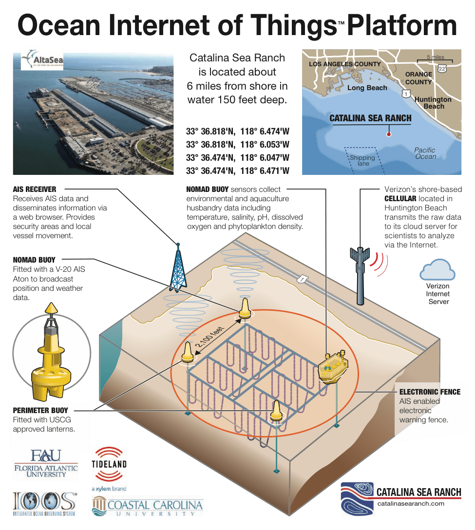
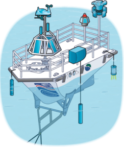
The National Oceanic and Atmospheric Administration (NOAA) Integrated Ocean Observation System (IOOS) provided a NOMAD buoy that will be anchored at our ranch and equipped numerous marine embedded sensors at strategic positions in the horizontal and vertical water plane. The wireless sensor network will help generate continuous real-time data, which will be transmitted to the cloud for remote and independent analysis by research institutions and to offer insights for offshore aquaculture operations.
Aquaculture husbandry metadata and analytics for predicting and producing higher ocean crop yields will become extremely valuable and could give the US a competitive economic advantage in aquaculture. Especially because the aquaculture sector is still young compared with land-based food production.
As well as monitoring ocean acidification and offering insights for offshore aquaculture operations, we also intend to prove to any doubters that our ranch operations have no negative environmental impact. Real-time monitoring with the Ocean IoT will enable taking the environmental pulse of an area of the ocean to understand short and long-term trends, anticipate problems and devise mitigation measures for immediate corrective actions. And this could lead to sound regulations based on solid science for advancing sustainable offshore aquaculture and responsible marine spatial planning.
In September 2015, NOAA announced its “Marine Aquaculture Strategic Plan FY 2016-2020” to reduce the $11 trillion seafood trade deficit in the US, with the goal of 50% increase in marine aquaculture activity. This amounts to over $600 million worth of production and highlights the need for innovative technology to help increase crop yields at the same time as provide environmental monitoring tools.
Marine Spatial Planning
We also intend to provide a model for marine spatial planning best practices to help other aquaculture operations avoid adverse impact liabilities associated with marine life, and coastal and ocean ecosystems.
Marine spatial planning is a public process of analyzing and allocating marine areas to achieve ecological, economic and social  objectives. An Ocean IoT platform would provide real-time scientific evidence allowing planners to consider various uses of the ocean for better decisions and policies in allocating this massive space for economic development that does not conflict with marine life and ocean ecology. Marine spatial planning not only include planning, but implementation, enforcement, monitoring, evaluation and adaptation based on new data and information to achieve goals and objectives. Coastal communities can then use this information to set economic, environmental and social goals.
So where is the technology coming from?
Washington State University’s School of Electrical Engineering & Computer Science has completed a prototype for a low-cost (approximately $150) chlorophyll fluorometer as an alternative to current high-end units costing thousands of dollars. This is the single most crucial and needed sensor for aquaculture because it measures the quantity of phytoplankton available for filter feeding shellfish. With deployment from simple buoys in strings of three at depths of 15, 30 and 45 feet in a wide spread of locations, it will be possible to maximize shellfish growth with optimum location and spacing of cultivation equipment.
Florida Atlantic University’s Institute for Sensing and Embedded Network
Systems Engineering (ISENSE) will be deploying a prototype of the Mote Stack, which is a hardware architecture and reference platform for constructing large-scale, long-lived, wireless data acquisition networks. The device is designed to enable data collection, data processing, data storage, and data communication across a broad range of sensor, storage and communication technologies. When deployed at scale, the devices form an intelligent sensing fabric that can cover a large geographic area with minimal power requirements at a low cost. While the architecture was originally conceived to suit the requirements of the Intelligent River program, it can also be applied to this project and collect water temperature, salinity, pH, dissolved and oxygen data.
The WiNES Lab at Northeastern University, College of Engineering is 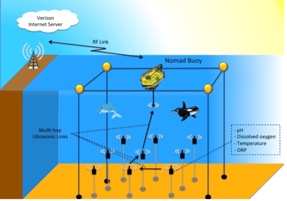 making a breakthrough in acoustic data transmission of bandwidth and distance with an order of magnitude beyond current devices. Underwater data transmission has until now so limited that it’s been unable to work with widely separated sensors. A prototype is being developed for evaluation of this project.
Coastal Carolina University is installing a compact weather station on the NOMAD for remotely monitoring wind speed, precipitation, atmospheric temperature, humidity, and pressure. With this data, their team of scientists can model outlooks of a threatening storm and track its characteristics. Their sophisticated model system will predict the depth, time and location of storm surges and water inundation.
Tideland Signal Corporation, a global water technology company, is providing the electronic perimeter fence whereby the automatic identification system (AIS) on the NOMAD transmits local vessel movement for to provide real-time security. This can be monitored remotely from CSR’s base of operations at AltaSea located 10 miles away from the ranch.
What do you think of this new initiative? Get in touch [email protected]

