The carbon footprint of the food and agriculture industries is under the spotlight more than ever. Consumers and governments have started demanding more transparency around the climate impact of different products and services. Companies of all sizes have jumped on the opportunity of providing that transparency through new approaches and practices — see the big agrifood companies‘ regenerative farming commitments as an example — to new technologies promising to pay farmers for sequestering carbon in their soil, and helping them to do it.
The latter centers around verification of how much carbon is in the soil, and ranges from drone and satellite imagery, to soil sampling technology, to marketplace tools. And it’s complicated stuff, with large amounts of variance between different geographies, soil types, and even within a single field. Furthermore, there’s the issue of knowing how long carbon will stay in the soil — permanence — and how long it was there before any verification happened, which makes accuracy and precision a big challenge to contend with.
Taking what it claims is a differentiated and more accurate approach to this measurement and verification challenge is CarbonSpace. The Dublin, Ireland-headquartered startup is using (mostly) satellite data to measure changes in atmospheric greenhouse gas emissions, starting with carbon dioxide, instead of measuring soil carbon. It just raised €900,000 ($1.04 million) seed funding in a round led by The Yield Lab Europe. Fellow accelerator-VC Rockstart is co-investing.
CarbonSpace will use the funding to help it scale its business in the EU and the US with a focus on food and forestry supply chains; to strengthen its technology core by integrating new sources of data and optimizing machine learning algorithms; and to finalize the self-onboarding platform; and to develop new products.
How does it work?
At the customer end, it’s supposedly simple; upload a shapefile of your land, and CarbonSpace will return information about emissions from that land with a resolution of as little as one hectare.
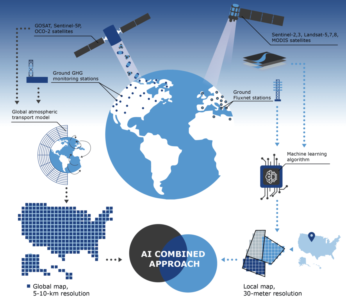
At the backend, it’s highly complex, involving what CarbonSpace calls a “top-down, bottom-up approach” to combining different data points at varying resolutions to measure what’s happening on the land (bottom-up) separately from what’s happening in the atmosphere (top-down.)
It uses various spectra of data from satellites, including near-infrared for greenhouse gas concentrations in the atmosphere; multispectral imagery for information about the surface, such as carbon sequestration; and radar for biomass measurements. It also takes in ground data from Fluxnet stations and crop inventories.

The startup’s core intellectual property centers on its machine learning algorithms and the combination of data it ingests, according to CEO Oleg Demidov. But the company’s speed to market and “unique” approach also give it an advantage, he told AFN.
“We are completely focused on CO2, which is not the case for others; they are often trying to provide multiple solutions for farmers and they start with agronomic information around soil health, for example, which makes the carbon data mostly a byproduct,” said Demidov.
Connie Bowen, investments manager at The Yield Lab, said that CarbonSpace can make verification cheaper and easier for stakeholders while enabling improved land management.
“Most of the conversation in ag is around monitoring soil carbon, and most of that monitoring is done via practice-based models, which are perhaps prohibitively burdensome to collect input data for. Furthermore, they’re neither very accurate nor are they very precise,” she told AFN.
“CarbonSpace increases relative precision, which is what actually matters when you’re trying to figure out if agronomic practice changes are yielding positive or negative emissions changes.”


