US soil mapping startup EarthOptics has raised $10.3 million in a Series A round led by Bayer‘s investment arm Leaps by Bayer. Also joining was new investor S2G Ventures and earlier backers FHB Ventures, Route 66 Ventures, and Middleland Capital’s VTC Ventures.
Bayer is an existing investor in EarthOptics through a corporate partnership fund, having backed the startup after it came through an accelerator program during its stint at Research Triangle Park in North Carolina.
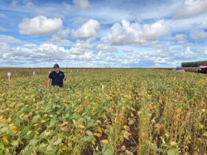
EarthOptics’ goal is to transform soil measurement and analysis approaches to give farmers the most accurate view of their soil’s health, compaction, and carbon content.
Although the technology is partly intended to support the burgeoning carbon credit market, farmers can also harness its insights to improve their production practices, reduce input use, and boost yields.
“We think we’re a little bit different because we’re taking a fairly pragmatic approach around measurements,” Lars Dyrud, CEO at EarthOptics, tells AFN. “We are very interested in soil and think it is the solution to a much more sustainable future for all of us – not just with food, but with carbon as well. The key to unlocking all those future promises is good measurements.”
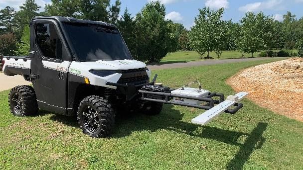
The Arlington, Virginia-based startup begins with soil sampling, using the its GroundOwl sensor suite which is designed to minimize the required number of manual samples. The tool can be mounted on a utility terrain vehicle, and uses ground-penetrating radar and electromagnetic induction sensors that can take measurements at speed without soil contact.
EarthOptics then converts that gathered data into a series of user-friendly maps with its machine learning applications, TillMapper and C-Mapper.
Cargill, Microsoft join $17 million round for carbon verification platform Regrow – read the AFN exclusive here
TillMapper, which was the startup’s first product, offers a three-dimensional view of soil compaction to help farmers decide if, when, where, and how deep to apply tillage. By tilling only where needed, farmers can make cost-savings in fuel, equipment, and labor – and they can limit the amount of carbon released through the process.
“There is a lot of money spent unnecessarily tilling the soil in the US and worldwide,” Dyrud says. “The problem is, you don’t know where the spots that don’t need tillage are located.”
“Our product allows growers, for the very first time, to identify in a detailed fashion where they do and do not have compaction problems. The net result is dramatically reduced soil disturbance,” he adds.
Dyrud estimates that TillMapper can save farmers roughly $15 per acre because less than 30% to 40% of a field usually needs tilling.
Meanwhile, C-Mapper aims to provide producers with carbon verification at a fraction of the cost of traditional soil core methods.
Today, C-Mapper primarily provides carbon verification services for existing carbon markets. But it hopes to expand its activities in the sector as it grows. The eventual goal is to work with growers to help them identify carbon credit purchasing opportunities. But for now, simply identifying a baseline for soil carbon content is important work, Dyrud says.
“We can help growers understand what’s working and what is not working. This allows them to avoid having to make a decision today, or lock themselves into a long-term, five-to-10 year carbon credit program,” he continues. “But because they have a valid baseline from our map, they can make a future decision on which carbon marketplace they might want to go with.”
Users are charged $3 per acre for C-Mapper, while TillMapper runs between $2 and $3 per acre.
Beyond farming
As EarthOptics gains more users and more data, it aims to wrap it all up into a broader mapping app called SoilCloud that will provide farmers with information about soil health, compaction, and carbon while taking fewer and fewer samples over time.
“Different stakeholders, including the grower, have interest in different data sets,” Dyrud says.
“The retailer that a farmer gets their fertilizer from certainly wants to know what the [nitrogen, phosphorus, and potassium] levels are in the soil every year. A carbon marketplace wants to know what the carbon levels are and a grower wants to know what the soil compaction is like.”
Soil health, compaction, and carbon are just the beginning for EarthOptics, according to Dyrud. The startup already has ambitions around soil moisture mapping and soil nutrient fertility mapping, and is aiming to extend its services to the construction industry – providing developers, contractors, and municipalities with information about the ground’s integrity before building projects begin.
And while much of its focus at the moment is around the crop industry, livestock producers interested in regenerative grazing are also a promising market for EarthOptics.
“A big problem for livestock grazing is that you’ve got heavy cattle that have been trampling over fields for many decades in some cases. Compaction is often the number one problem with the productivity on those lands,” Dyrud says.
“We can identify where they have problems so they can decide what to do with them. And, of course, carbon is another new exciting potential revenue stream for grazing land as well.”