One day, NASA will tell you how well your crops are doing.
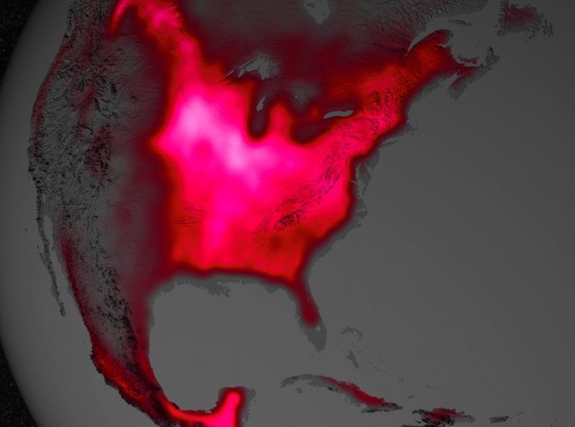
A recent study from the National Academy of Sciences has shown that the US Corn Belt is the most productive place on earth, and that’s not the coolest part. The way researchers figured it out was by using satellites to track plant productivity.
In 2013, scientist Joanna Joiner of NASA’s Goddard Space Flight Center figured out how to detect the tiny fractions of fluorescence that plants’ chlorophyll emit during photosynthesis. Then using this data collected from satellites, (which, by the way, were meant for entirely different purpose,) researcher Luis Guanter of the Freie Universität Berlin figured out that some of this information could be used to learn about agriculture.
“The paper shows that fluorescence is a much better proxy for agricultural productivity than anything we’ve had before,” wrote co-author Christian Frankenberg of NASA’s Jet Propulsion Labaratory. “This can go a long way regarding monitoring – and maybe even predicting – regional crop yields.”
The Midwest was the area of interest for the study, which showed that in July, florescence levels released in the Corn Belt are 40 percent higher than any in the Amazon. These results were confirmed by comparing the statistics to ground-based measurements from carbon flux towers.
And not only is this method of measurement accurate, but also highly resolute. According to a release from NASA, while ground-based models have a resolution at about 0.4 square miles, satellite measurements have a resolution of more than 1,158 square miles.
There is more to be learned about how this kind of imagery can be put to better use for ag. For example, the data used does not separating ag-land from simple vegetation, and there is more information to dive into to determine how specific farmers’ lands are doing.
Despite the drawbacks, realization is certainly one small step for NASA and one giant leap for agriculture.
FEATURED PHOTO: NASA’s Goddard Space Flight Center


